Strong winter storm to blast 10 states with snow this week
Although March is the first month of meteorological spring, a powerful winter storm is set to bring snow and ice to millions of people from the Midwest to the Northeast late this week.
The warm side of the storm system will also spawn a severe weather threat across the South each day through Friday.
After burying California’s Sierra Nevada mountain range under feet of snow amid blizzard conditions, the snow from this storm will spread from the southern Rockies into the central Plains on Thursday.
The winter storm is expected to produce a large area of snow, sleet, and freezing rain Friday, extending from eastern Kansas to the southern Great Lakes and interior Northeast.
Rain is expected initially in parts of the Midwest and Great Lakes, but it will gradually transition to a wintry mix or snow as colder air arrives.

“You’re going to need to be on alert here because depending on where you are, that is going to pretty much dictate what type of moisture you are going to end up seeing,” FOX Weather meteorologist Jason Frazer said.
Areas along Interstate 95 from the New York City tri-state area and points south will likely see mainly rain from this storm system. However, much of New England, including Boston, is expected to see a changeover to a wintry mix or snow by late Friday.
The wind will also be a concern as the area of low-pressure slides eastward across the region. Wind gusts between 40 and 50 mph are possible from St. Louis to Nashville, Tennessee, with gusts between 50 and 60 mph possible in West Virginia, western Pennsylvania, and northern Ohio.

The action from the winter storm is expected to be centered over upstate New York by Saturday, with rain and snow showers lingering from the eastern Great Lakes to New England before ending late Saturday.
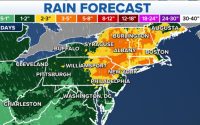
A swath of snow totals between 3 and 5 inches is likely from Iowa through southern Wisconsin, far northern Illinois and northeastern Lower Michigan, with lower amounts expected elsewhere in the Great Lakes region.
Some areas, however, could see higher amounts. Milwaukee, Wisconsin, could see between 5 and 8 inches of snow.
Higher snow totals are likely from the interior Northeast to New England.
Much of Vermont, New Hampshire and Maine, as well as the Adirondacks of New York, can expect 8-12 inches of snow. More than a foot of snowfall is possible in the highest elevations of New Hampshire’s White Mountains.

Areas from upstate New York to central New England, including parts of the Boston metro area, are forecast to receive 5-8 inches of snow.
Snow totals between 3 and 5 inches are possible across interior southern New England, northern Pennsylvania and southern portions of New York state.
Less than 3 inches of snow is predicted across northern New Jersey and the remainder of Pennsylvania. Little to no snowfall is expected along Interstate 95 in New York City and Philadelphia.
Ice is also a concern from the Great Lakes to the Northeast, but significant impacts aren’t expected.
There’s a chance for a glaze of ice in southern Michigan, northeastern Indiana and northwestern Ohio.
In the Northeast, the ice threat will be centered across western Pennsylvania and portions of western Maryland and northern West Virginia.
In addition, a glaze is possible in the Hudson Valley in New York, and in the higher elevations in New England from Connecticut to New Hampshire and Vermont.

UK to be slammed with snow following record-breaking low temps

‘Time to Bud Light them’